
2019 Nav-X Challenge @ Dinkey Creek
2019 North American Rogaining Championships
Update: Event Date has been moved from Sept 7-8 to Sept 14-15
Update: We are now allowing day of registration for 24h event, Directions to event have been updated (9/12/2019)
UPDATE: COURSE SETTER NOTES - CLICK HERE
Quick Info
Date: Saturday & Sunday, Sept 14-15, 2019
Location: Sierra National Forest near Shaver Lake, California
Event Director: Gavin Wyatt-Mair (contact)
Course Director: Dennis Wilkinson
Courses: 4, 8 & 24h Map Trek (Rogaine); teams of 2+ required for 8 and 24 hr
List of Registered Entrants
Follow this link to an updated list of entrants.
Event Summary
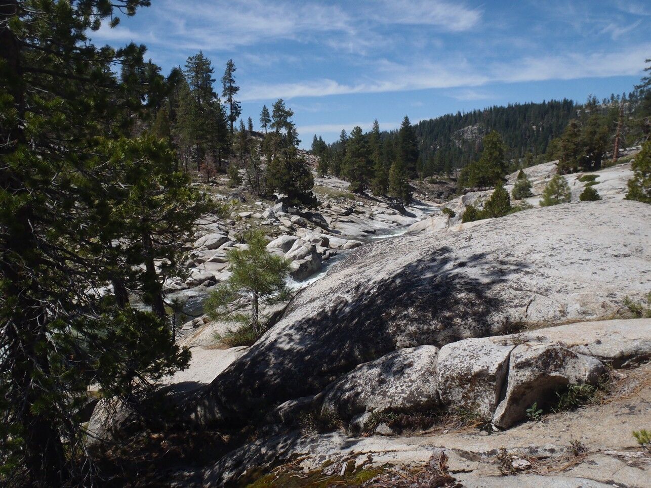
This event, the 4th event in the 2019 Nav-X race series, will also serve as the 2019 North American Rogaining Championships for the 24-hr race (sanctioned by Orienteering USA). Race or trek in the Sierra Nevada mountains east of Fresno at elevations between 7000 and 9000 feet! The race area is primarily pine forest with low to moderate undergrowth, interspersed with some bare granite slab. Steepness is moderate by California standards, with some dramatic terrain and spectacular views mixed in. The map was made by Bill Cusworth in 2016 using USGS contour data combined with features derived by aerial photos such as roads and vegetation boundaries. The map is 1:25000 scale with 10 meter contours and uses mostly standard orienteering symbols but with a few new symbols to delineate the different types of granite areas from one another. Come experience the true wildness of Sierra Nevada mountains to challenge yourself, and the top North American navigators!
Top finishers in each division of the 24-hr qualify for the World Rogaining Championships in 2020 at Tahoe-Northstar. Scores from the 24 hour race, as well as the 4 and 8 hour races, will also count towards the 2019 Nav-X Challenge Series. Teams are required in the 8 and 24 hour divisions for safety. Each participant in the 24-hr event will be provided a high capacity SI-Air e-stick and team members will be required to punch in at controls within one minute of each other.
Schedule
| Friday Sept 13 | |||
|---|---|---|---|
| Camping is allowed near the start/finish/hash house area (permit not required per NFS rules for dispersed camping) but not in the Sno-Park parking lot. | |||
| Saturday Sept 14 | |||
| Time | Long Course - 24h | Medium Course - 8h | Short Course - 4h |
| 6:11 | Civil Twilight | ||
| 6:37 | Sunrise | ||
| 8:00 | Event center and hash house setup begins | ||
| 8:30 | Maps available | ||
| 9:40 | Briefing, 8-hour division; 8-hour intention sheets due | ||
| 10:00 | Mass Start | ||
| 10:40 | Briefing, 4-hour division; 4-hour intention sheets due | ||
| 11:00 | Mass Start | ||
| 11:40 | Briefing, 24-hour divisions; 24-hour intention sheets due | ||
| 12:00 | Mass Start | ||
| 14:30 | Food service begins at Hash House | ||
| 15:00 | Finish | ||
| 15:30 | Awards | ||
| 18:00 | Finish | ||
| 18:30 | Awards | ||
| 19:07 | Sunset | ||
| 19:33 | Civil twilight ends | ||
| Sunday Sept 15 | |||
| 6:12 | Civil twilight begins | ||
| 6:38 | Sunrise | ||
| 12:00 | Finish | ||
| 12:30 | Awards | ||
| 13:30 | Food service ends | ||
| 19:06 | Sunset | ||
| 20:00 | All people and equipment out of the Staging area | ||
New to Map Trekking or Rogaining?
Map Trekking is a “Navigation Sport” that has elements of a few other sports and activities like Trail Running, Fell Running (XC hill running), Hiking, Orienteering and Geo Caching. More specifically, Map Trekking is a time-based challenge, 2 hrs or more in length, where participants try to score as many points as possible within the time allowed, by visiting checkpoints scattered across a vast, wild landscape. Participants are free to decide which checkpoints to visit, and in what order. Typically, a set time is allowed before the start for participants to study the map, and determine their route. Participants travel on foot and navigate their chosen route using the map and a compass (No GPS allowed except for recording your track). A late finish comes with point penalties, adding another layer of challenge to the sport. Checkpoints vary in difficulty and the point value reflects the same, so that easy ones yield a lower point value than difficult ones. To encourage beginners, course setters typically provide plenty of easy checkpoints near the start and finish location.
In longer rogaines, participants may return to the “hash house” to rest and eat. Hot food is provided and some racers elect to lay down for a few hours. At this event, the hash house will be located at the start/finish/staging area. You are free to set up camp in the forest near the hash house, to spend the night before the race or if you think you might rest during the 24 hour event.
Venue / Park Info
The Sierra Nevada mountains of California are world famous for their beauty and wildness. However, almost all of the upper elevations (High Sierra) is federally designated Wilderness and therefore forbidden for organized group events or races. We have identified one of the last remaining large, permittable regions above 7000 feet and are excited to bring you the 2019 North American Rogaining Championships in this dramatic venue! The race area has moderate undergrowth and steepness, by California standards, and is large enough that top 24 hour teams will find it difficult to clear the course.
Moderate (local) steepness aside, you will definitely need your climbing legs for this race. The event area is characterized by major canyon systems divided by ridges, with elevation differences of 2000 feet or more. The vegetation is largely pine forest, with some bare granite slab or open sandy ground on the mountaintops and some canyon sides. Undergrowth is patchy but will be a factor, so leg protection is suggested; deadfall can also be an impediment. You may also encounter limited areas of alpine meadow, talus slope, dense stands of young trees, or thick chaparral. You will not encounter poison oak, which does not grow at these elevations. There is a road network, although some of the smaller use roads may not be well maintained or mapped.
About the Map
The map was made by Bill Cusworth in 2016 using USGS contour data combined with features derived by aerial photos such as roads and vegetation boundaries. The map is 1:25000 scale with 10 meter contours and uses mostly standard orienteering symbols but with a few new symbols to delineate the different types of granite areas from one another.
Courses & Divisions
The course options are 4 hour, 8 hour and 24 hour. Solo racers are only allowed in the 4 hour course, although teams are welcome as well. Teams of 2-5 are required for the 8 and 24 hour courses.
We will recognize the top finishers as follows. The 24 hour course will serve as the 2019 North American Rogaining Championships and qualifier for the 2020 World Rogaining Championships in Tahoe-Northstar. Men’s, women’s, and mixed teams will be separately ranked in the following age groups:
Open (any age)
Youth (22 or younger)
Veteran (40 or older)
Super Veteran (55 or older)
Ultra Veteran (65 or older)
Teams qualifying for two or more of the above divisions will be ranked in each. The top two or three teams in each division qualify for the World Rogaining Championships according to IRF guidelines (see rogaining.com for more details).
Finishers in the 4 and 8 hour courses will also be ranked and recognized according to the standard Nav-X divisions as these durations are not Championship courses. Solos and teams will be ranked together in the 4 hour results.
Finishers will also receive points and be ranked in the 2019 Nav-X Series. The Nav-X divisions are:
Junior (Under 20, Solo or 2-5 person teams, any gender)
Open Female (20-49, Solo or 2-5 person teams, All Female)
Open Male (20-49, Solo or 2-5 person teams, All Male)
Open Mixed (20-49, Solo or 2-5 person teams, Mixed Male-Female)
Masters Female (50 and up, Solo or 2-5 person teams, All Female)
Masters Male (50 and up, Solo or 2-5 person teams, All Male)
Masters Mixed (50 and up, Solo or 2-5 person teams, Mixed Male-Female)
Family- Adult (20 and up + Children (12&under), 2-5 person teams, 4-hr course only)
Price
Early fees (20% off) through Aug 30th (via online registration). Regular fee is Aug 31st - Sept 11th (via online registration). Day of Event Registration is cash or check only.
The below fees apply for Nav-X 4/8/24 hr events in the Series in 2019. From these base prices, adult (20+) orienteering club members can subtract $3 and for the 24-hr championship only, OUSA members can subtract $4 for adults and $2 for juniors.
For family teams (4-hr course only), it is required to have at least one adult (20 & over) and at least one child (12 & under). Children 12 & under race free. Children must be registered and accompanied by an adult.
Additional fees to rent an e-punch ($5) and/or compass ($2). Only one e-punch number or rental request is required per team for the 4 & 8h course, while for the 24h course, each team member is required to have an e-punch. On the registration page, please enter "0" for e-punch number if you are not the first person registering for your team. No e-punch trade-ins allowed (ie. to get a higher punch count e-punch).
| 4h Pricing | |||
|---|---|---|---|
| Early Registration | Regular Registration | Day of Event Registration | |
| Junior (19 & Under) | $20 | $23 | $25 |
| Adult (20+) | $40 | $45 | $50 |
| 8h Pricing | |||
|---|---|---|---|
| Early Registration | Regular Registration | Day of Event Registration | |
| Junior (19 & Under) | $32 | $36 | $40 |
| Adult (20+) | $64 | $72 | $80 |
| 24h Pricing | |||
|---|---|---|---|
| Early Registration | Regular Registration | Day of Event Registration | |
| Junior (19 & Under) | $53 | $60 | $67 |
| Adult (20+) | $106 | $120 | $135 |
Refund Policy
Refund policy: 100% refund up to 10 days before event. Future race credit 1-9 days before event. No refunds for no-show.
What to Bring
Because of the length and extreme terrain in this event, certain gear items are required for safety in this event. Required gear for all divisions is:
Course map
Compass
Whistle
Watch
E-punch stick (may be rented for $5)
In addition, the following items are required for the 8 and 24 hour divisions:
Working headlamp or flashlight
1.5L (50 oz) water-carrying capacity
Emergency blanket
And finally, the following items are additionally required for the 24 hour divisions:
At least 800 calories of food
Water purification
Warm clothing and/or rain gear
Lastly, we recommend the following items:
Visor hat, sunscreen, and other sun protection as you prefer
Pen and/or highlighter marker (for marking up your map and making notes)
3L (100 oz.) water carrying capacity
200-250 calories of food per hour
Sturdy trail running shoes with good traction
Leg protection (long pants, knee or ankle gaiters)
On the go snacks (energy bar, gel, etc.
Race for Less - Volunteer!
Get a discount off your race fees if you help us out! 4 and 8 hour participants, stay and help us at the hash house for a 20% discount on your entry. We’d especially love to find some night owls to keep us company in the small hours, and people to help set up or take down the event center.
We are also very motivated to find volunteers for control pickup after the race! This will happen on Sunday after 12:30, and as required during the week following the race. Your discount, or rebate, for this will be 2X% of the entry fee for X% of the points you pick up. So, for example, if you pick up 23% of the total points, you receive a 46% rebate on your entry fee (rebates not to exceed 100% for you extreme rogainers).
Contact Gavin if you’d like to volunteer. First come, first served!
Map and Directions
From the town Shaver Lake, take CA 168 east approximately 11 miles to the Tamarack Sno-park lot, on the right just after the "Tamarack Ridge elev 7582" sign.
Turn into the lot, go through, and continue straight onto a major dirt road. This is Rock Creek Rd, though there are few signs. Stay on this road for 2.1 miles. It bends around, and there are some unsigned turnoffs, but the main road is quite wide and clear. You will see the event center on the left side of the road after 2.1 miles. Parking is in the event center area. Correct coordinates are 37.1450, -119.193 for the event center.