
2016 Nav-X Challenge @ High Sierra
North American Rogaine Championships, 2016
First annual Western NA Rogaine
Quick Info
Date: Saturday August 27 - Sunday August 28, 2016
Location: Sierra National Forest near Shaver Lake, California
Event Director: Dennis Wilkinson (contact), Rex Winterbottom (contact)
Course Directors: Dennis Wilkinson
Courses: 4, 8 & 24 hr Map Trek (Rogaine); teams of 2+ required for 8 and 24 hr
Produced in cooperation with Bay Area Orienteering Club
Final Event Update Available! - 8/23/2016
Follow this link to the Course Setter Notes for our High Sierra Event.
Course Setter Notes Available! - 8/23/2016
Follow this link to the Course Setter Notes for our High Sierra Event.
List of Registered Entrants
Follow this link to an updated list of entrants.
Event summary
In addition to being the 2016 North American Rogaine Championships, this event will also be part of the 2016 Nav-X race series. Race or trek in the Sierra Nevada mountains east of Fresno at elevations between 7000 and 9000 feet! The race area is primarily pine forest with low to moderate undergrowth, interspersed with some bare granite slab. Steepness is moderate by California standards, with some dramatic terrain and spectacular views mixed in. The map will be a slightly improved USGS topo developed by the Nav-X team, most likely at 1:24000 scale.
Come experience the true wildness of the Sierra Nevada mountains to challenge yourself, and the top North American navigators!
This event is sanctioned by OrienteeringUSA, and the 24-hour race is the North American Rogaine Championship for 2016. Top finishers in each division of the 24-hour race qualify for the World Rogaining Championships. Scores from the 24-hour race, as well as the 4- and 8-hour races, will also count towards the 2016 Nav-X Challenge Series. For safety, teams are required in the 8- and 24-hour divisions.
(This event will be the first annual Western N.A. Rogaine. With rogainers from other western O clubs, we are developing a plan for an annual 24-hour event, rotating the hosting club.)
Schedule
| Friday Aug 26 | |
|---|---|
| Camping | Allowed near the Start/Finish/Hash House area (permit not required per NF) |
| Saturday Aug 27 | |
| 6:22 | Sunrise |
| 8:30 | Event Check-in (and Late Registration) |
| 9:30 | Maps available |
| 10:40 | Briefing, 8-hour division; 8-hour intention sheets due |
| 11:00 | Start, 8-hour division |
| 11:40 | Briefing, 4- and 24-hour divisions; 4- and 24-hour intention sheets due |
| 12:00 | Start, 4- and 24-hour divisions |
| 15:30 | Food service begins at Hash House |
| 16:00 | Finish, 4-hour division |
| 16:30 | Absolute deadline to finish, 4-hour division |
| 16:40 | Award ceremony, 4-hour division |
| 19:00 | Finish, 8-hour division |
| 19:30 | Absolute deadline to finish, 8-hour division |
| 19:40 | Award ceremony, 8-hour division |
| 19:33 | Sunset |
| 20:01 | Civil twilight ends |
| Sunday Aug 28 | |
| 5:57 | Civil twilight begins |
| 6:24 | Sunrise |
| 12:00 | Finish, 24-hour division |
| 12:30 | Absolute deadline to finish, 24-hour division |
| 12:40 | Awards ceremony, 24-hour division |
| 13:30 | Food service ends |
| 19:31 | Sunset |
| 20:00 | All people and equipment out of the Staging area |
New to Map Trekking or Rogaining?
Map Trekking is a “Navigation Sport” that has elements of a few other sports and activities like Trail Running, Fell Running (XC hill running), Hiking, Orienteering and Geo Caching. More specifically, Map Trekking is a time-based challenge, 2 hrs or more in length, where participants try to score as many points as possible within the time allowed, by visiting checkpoints scattered across a vast, wild landscape. Participants are free to decide which checkpoints to visit, and in what order. Typically, a set time is allowed before the start for participants to study the map, and determine their route. Participants travel on foot and navigate their chosen route using the map and a compass (No GPS allowed except for recording your track). A late finish comes with point penalties, adding another layer of challenge to the sport. Checkpoints vary in difficulty and the point value reflects the same, so that easy ones yield a lower point value than difficult ones. To encourage beginners, course setters typically provide plenty of easy checkpoints near the start and finish location.
Venue Info
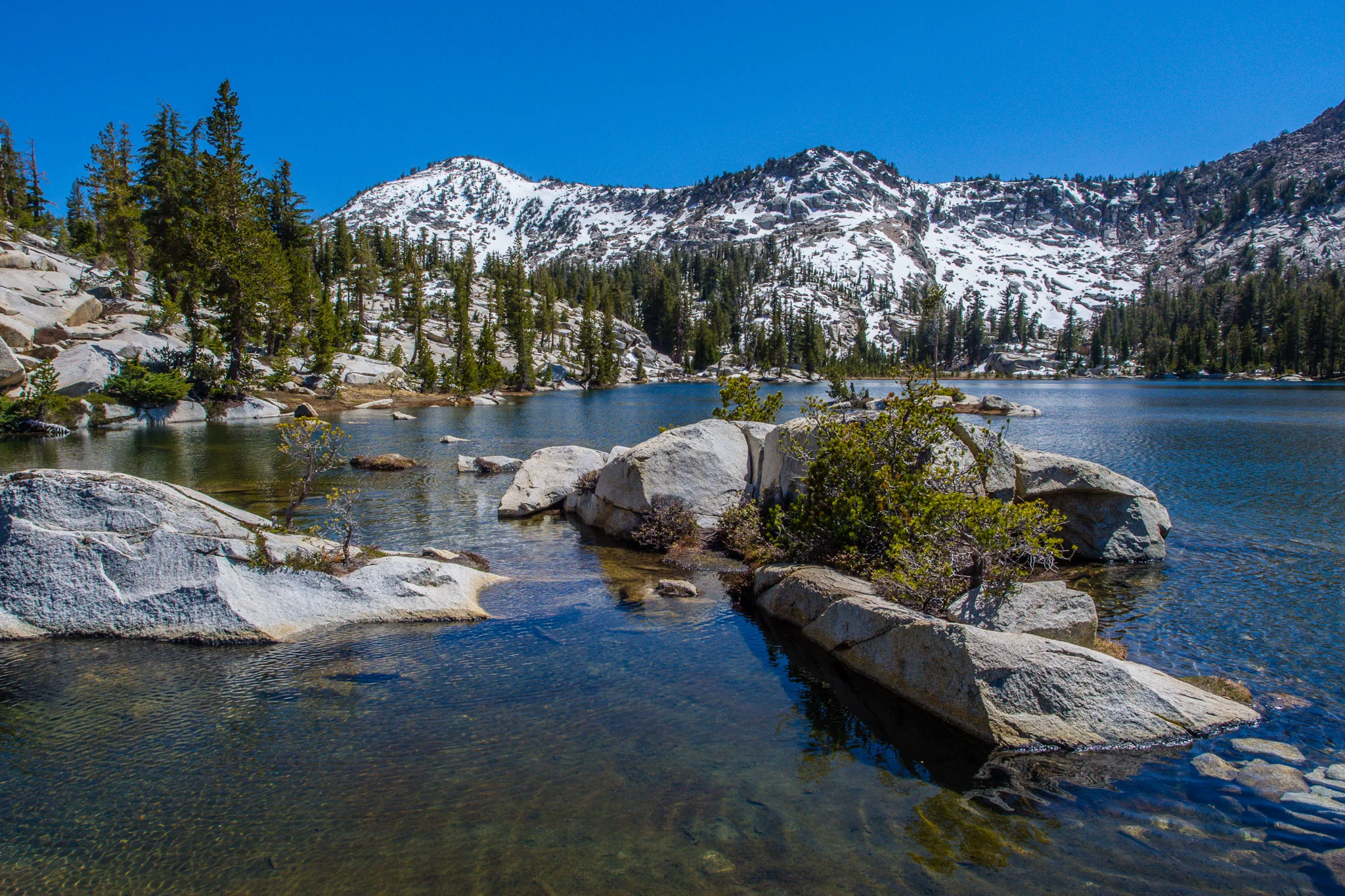
The Sierra Nevada mountains of California are world famous for their beauty and wildness. However, almost all of the upper elevations (High Sierra) is federally designated Wilderness, and therefore forbidden for organized group events or races. We have identified one of the last remaining large, permittable regions above 7000 feet, and are excited to bring you the 2016 North American Rogaine Championships in this dramatic venue! The race area has moderate undergrowth and steepness, by California standards, and is large enough that top 24-hour teams will find it difficult to clear the course.
Moderate (local) steepness aside, you will definitely need your climbing legs for this race. The event area is characterized by major canyon systems divided by ridges, with elevation differences of 2000 feet or more. The vegetation is largely pine forest, with some bare granite slab or open sandy ground on the mountaintops and some canyon sides. Undergrowth is patchy but will be a factor, so leg protection is suggested; deadfall can also be an impediment. You may also encounter limited areas of alpine meadow, talus slope, dense stands of young trees, or thick chaparral. You will not encounter poison oak, which does not grow at these elevations. There is a road network, although some of the smaller-use roads may not be well maintained or mapped.
There is currently legislation in progress that would convert around half of the terrain for this race into Wilderness designation, rendering it inaccessible for future racing. The timeline for this decision and change is the next 2 to 5 years. Come race in the Sierras while you can! If you'd like to take action to attempt to retain the ability to produce group events in this area, before or after the race, contact the event directors.
About the Map
The map for this race will be an improved USGS topo map. The current plan is to add three to five vegetation colors onto the contours, using a satellite photo. We are currently evaluating which of the terrain types to include on the map and the scale at which we will print the map.
Courses and Divisions
The course options are 4-hour, 8-hour and 24-hour. Solo racers are allowed only in the 4-hour division, although teams are welcome as well in that division. Teams of two or more people are required for the 8- and 24-hour divisions.
We will recognize the top finishers in the categories below. The 24-hour division is the North American Rogaining Championships, and men's, mixed, and women's teams will be separately ranked in the following age groups:
- Open
- Youth (22 or younger as of August 27)
- Veteran (40 or older as of August 27)
- Super Veteran (55 or older as of August 27)
- Ultra Veteran (65 or older as of August 27)
Teams qualifying for two or more of the above divisions will be ranked in each. The top two or three teams in each division qualify for the World Rogaining Championships according to IRF guidelines (see here for more details).
Finishers in the 4- and 8-hour courses will also be ranked and recognized according to the above scheme, although these durations are notChampionship courses. Solos and teams will be ranked together in the 4-hour results.
Finishers will also receive points and be ranked in the 2016 Nav-X Series. The Nav-X divisions are:
- Junior Mixed (Under 20, Solo or 2-person teams, All-male or mixed Male-Female)
- Junior Female (Under 20, Solo or 2-person teams, All-female)
- Open Mixed (20–49, Solo or 2-person teams, All-male or mixed Male-Female)
- Open Female (20–49, Solo or 2-person teams, All-female)
- Masters Mixed (50 and up, Solo or 2-person teams, All-male or mixed Male-Female)
- Masters Female (50 and up, Solo or 2-person teams, All-female)
Results from this event count toward the Nav-X Series Championship. However, recognition and awards for individuals and teams will be allotted according to the Rogaine divisions. So, for example, a 21-year-old male competitor in the 4-hour race will be ranked in the Youth Male division for this event, while his score also contributes to his total in the Open Mixed category of the Nav-X Series. Team members each receive the same number of (individual) Nav-X points.
Fees
The fees below apply for 4/8/24-hour events in the 2016 Nav-X Series. Early Registration ends at 11:59 PM July 31st 2016. Regular Registration ends at 11:59 PM August 23 2016. Late (day of) registration will NOT be supported in the 24-hr divisions.
| Early Registration | Regular Registration | Late Registration | |||||||
|---|---|---|---|---|---|---|---|---|---|
| Course Length | 4h | 8h | 24h | 4h | 8h | 24h | 4h | 8h | 24h |
| Junior (under 20) | $25 | $44 | $66 | $27 | $48 | $75 | $31 | $55 | N/A |
| Adult (20+) | $41 | $73 | $110 | $45 | $80 | $125 | $51 | $91 | N/A |
Online Registration is available here. You can see who is registered here.
What to Bring
Because of the length and extreme terrain of this event, certain gear items are required for safety in this event.
Required gear for all divisions:
- Course map
- Compass
- Whistle
- Watch
- E-punch stick (may be rented for $5)
- Possibly, cell phone (to be determined, depending on coverage)
The following items are additionally required for the 8- and 24-hour divisions:
- Working headlamp or flashlight
- 1.5-liter (50 oz) water-carrying capacity
- Emergency blanket
And finally, the following items are additionally required for the 24-hour division:
- At least 800 calories of food
- Water purification
- Warm clothing and/or rain gear
In addition to that required gear, we recommend the following items:
- Visor hat, sunscreen, and other sun protection, as you prefer
- Pen and/or highlighter marker (for marking up your map and making notes)
- 3-liter (100 oz.) water carrying capacity
- 200–250 calories of food per hour
- Sturdy trail-running shoes with good traction
- Leg protection (long pants, knee or ankle gaiters)
- On-the-go snacks (energy bar, gel, etc.)
Race for Less — Volunteer!
Get a discount off your race fees if you help us out! 4- and 8-hour participants, stay and help us at the Hash House for a 20% discount on your entry. We'd especially love to find some night owls to keep us company in the small hours, and people to help set up or take down the event center.
We are also very motivated to find volunteers for control pickup after the race! This will happen on Sunday after 12:30, and during the week following the race (as required). Your discount, or rebate, for this will be 2×N% of the entry fee for N% of the total points that you pick up. For example, if you pick up 23% of the total points, you receive a 46% rebate on your entry fee (rebates not to exceed 100% for you extreme rogainers).
Contact Dennis or Rex if you'd like to volunteer. First come, first served!
Event Location
The Staging/Start/Finish/Hash House area will be just off the Tamarack Snopark lot on CA highway 168, 11.2 miles east of Shaver Lake, CA. Coordinates for this location are 37.162431,-119.201777. Overflow parking will be available 500 m north at the Coyote Snopark. The nearest large airport is Fresno, CA, around 60 miles away.
There's a map here that shows the location of the event.